
What you will find on this page: how climate change shapes food insecurity (video); Weather Alert: 4 Corners program (video); About time we got over the “yuk” factor for recycled water (video); Farmers for Climate Action (video); Cool Farm Tool online calulator; Australia’s future food security; WRI Challenge; UNEP summary; BOM water sites: Australia’s water challenge; climate drivers; understanding ENSO (video); groundwater use; water futures; water trading; agriculture; food & water crisis; localising food production; complex food distribution; land use – agriculture & forestry; latest news; also refer to page “impacts observed & projected” as the issues are closely related
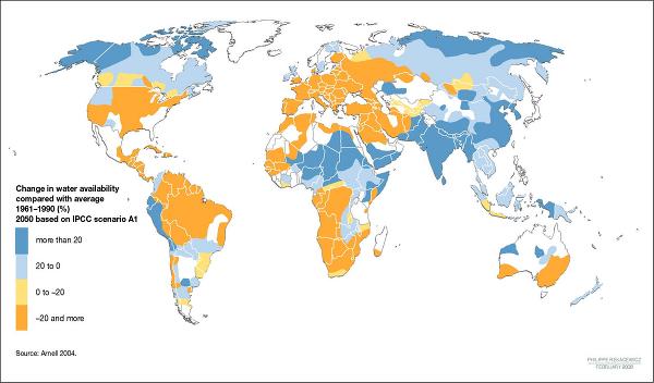
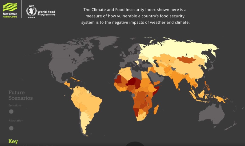
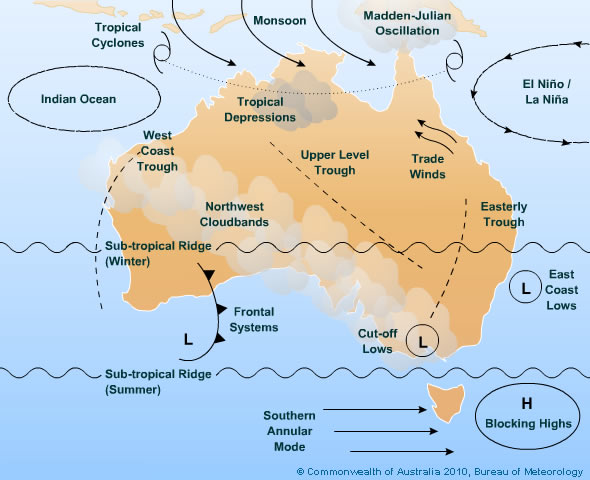
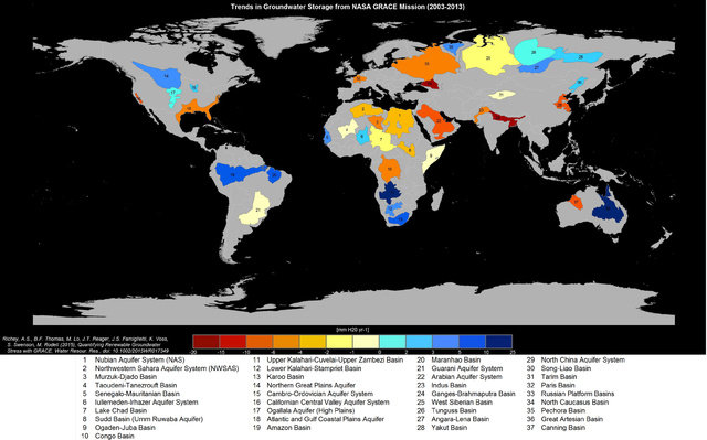
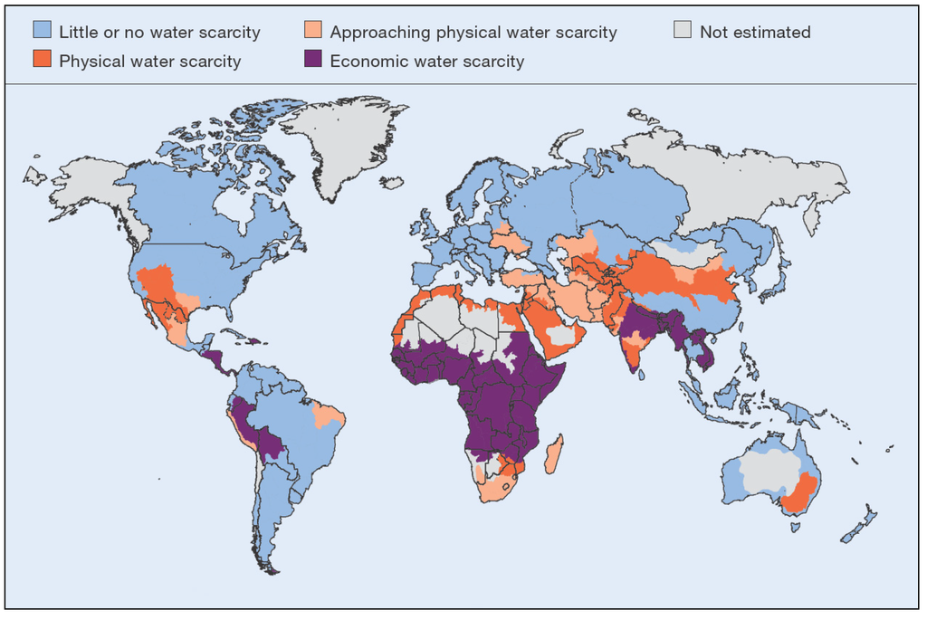
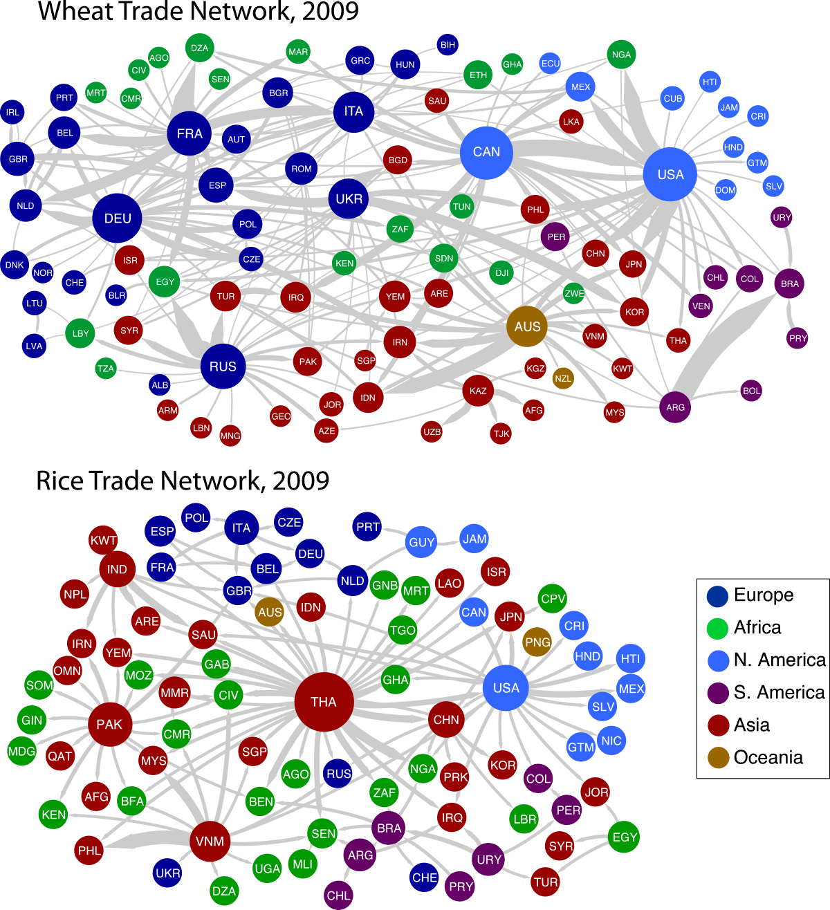
Latest News 19 September 2016, The Conversation, Disruption over Macquarie Island calls for some clever Antarctic thinking. The fate of the Australian Antarctic Division’s research base on Macquarie Island hangs in the balance, after last week’s surprise announcement that it would close in March 2017 was followed on Friday by a suggestion that the government could yet reprieve it. Why all the fuss over a scattering of buildings on a windswept island (admittedly a UNESCO World Heritage-listed one) perched on a tectonic ridge halfway between Australia and Antarctica? Macquarie Island is the perfect natural laboratory for scientific research. Unique climate, geological, biological and astronomical measurements are collected year-round. The data is fed into many large-scale, international science programs and reports, including those published by the Intergovernmental Panel on Climate Change. It is something of an anomaly in Australia’s national Antarctic program. Unlike Heard Island, Macquarie Island lies outside the areas covered by the Antarctic Treaty and the Convention on the Conservation of Antarctic Marine Living Resources. The Tasmanian government manages the island. The buildings at the island’s north end are home to research infrastructure and accommodation for various organisations. These include the Tasmanian Parks and Wildlife Service, the Bureau of Meteorology, and the Australian Radiation Protection and Nuclear Safety Agency, which monitors the Southern Ocean for evidence of nuclear events. These buildings are increasingly exposed to ocean inundation. Read More here 19 September 2016, The Guardian, Adani Carmichael coalmine faces new legal challenge from conservation foundation. Foundation appeals against ruling that endorsed mine’s approval by the commonwealth. The Australian Conservation Foundation has renewed its legal challenge to Adani’s Carmichael mine, appealing against a federal court ruling that endorsed its approval by the commonwealth. The ACF on Monday lodged an appeal against last month’s decision, which found the then federal environment minister, Greg Hunt, was entitled to find the impact on global warming and the Great Barrier Reef from the Queensland mine’s 4.6bn tonnes of carbon emissions “speculative”. The president of the ACF, Geoff Cousins, said Australia’s national environment protection laws were “broken” if the minister could approve “a mega-polluting coalmine – the biggest in Australia’s history – and claim it will have no impact on the global warming and the reef”. “If our environment laws are too weak to actually protect Australia’s unique species and places, they effectively give companies like Adani a licence to kill,” Cousins said. “Be in no doubt, Adani’s Carmichael proposal is massive and will lock in decades of damaging climate pollution if it goes ahead, further wrecking the reef. “The science is clear that we can have coal or the reef – but we can’t have both.” Read More here 15 September 2016, Energy Post, UK government approves Hinkley Point C. The UK Department of Business, Energy and Industrial Strategy announced this morning that the government goes ahead with the Hinkley Point C nuclear power project. This is a very important decision for the nuclear energy sector in Europe, especially EDF, and energy policy in general. Below we give the literal text of the press release put out by the UK Department of Business, Energy and Industrial Strategy, explaining that the government is taking extra precautions to ensure that it is able at all times to control its nuclear industry, after concerns about the Chinese involvement in the project. There is no change in the “strike price” of 92.50 pounds per MWh (inflation-proof, 35 years) that has been agreed with builders EDF, which has been criticized by many as too expensive. “Following a comprehensive review of the Hinkley Point C project, and a revised agreement with EDF, the Government has decided to proceed with the first new nuclear power station for a generation. However, ministers will impose a new legal framework for future foreign investment in Britain’s critical infrastructure, which will include nuclear energy and apply after Hinkley. The agreement in principle with EDF means that: The Government will be able to prevent the sale of EDF’s controlling stake prior to the completion of construction, without the prior notification and agreement of ministers. This agreement will be confirmed in an exchange of letters between the Government and EDF. Existing legal powers, and the new legal framework, will mean that the Government is able to intervene in the sale of EDF’s stake once Hinkley is operational. The new legal framework for future foreign investment in British critical infrastructure will mean that: After Hinkley, the British Government will take a special share in all future nuclear new build projects. This will ensure that significant stakes cannot be sold without the Government’s knowledge or consent. Read More here 15 September 2016, The Conversation, After Tasmania’s year of disasters, bushfire tops the state’s growing list of natural hazards. Tasmania has had a damaging year, with the island state hit by a series of bushfires and floods. Now a comprehensive new assessment of Tasmania’s exposure to natural disasters shows that bushfire remains the number one hazard to people and property, while also highlighting a range of new threats. These include coastal flooding, pandemic influenza and – despite being Australia’s most southerly state – an increasing likelihood of heatwaves. The 2016 Tasmanian State Natural Disaster Risk Assessment (TSNDRA)aims to provide emergency services with key information to help prepare for and reduce the impact of disasters. It is the first state-level assessment in Australia that adheres to the recently updated National Emergency Risk Assessment Guidelines. All states and territories are required to produce their own risk assessments by June 2017. Given Tasmania’s unprecedented recent run of natural disasters, it is fitting that it should be the first state to publish a comprehensive roundup of the risks. The assessment of natural disaster risk took place over 12 months from March 2015. It involved a series of workshops and online surveys of experts in each hazard area. For the first time, the process was led not by state government agencies, but by a close collaboration between researchers at the University of Tasmania, RMIT University and the Antarctic Climate & Ecosystems Cooperative Research Centre, together with members of the State Emergency Service and related agencies, and other stakeholders including the Bureau of Meteorology, Australian Red Cross and Engineers Australia. The process aimed to allow a range of different voices to inform the identification of priority risks for Tasmania. Read more here End Latest News Change in water availability compared with average 1961 – 1990 Interactive: How climate change shapes food insecurity across the world 1 December 2015, Carbon Brief: Rising temperatures and more extreme weather are set to increase the pressure on food supplies around the world, risking shortages in the least-developed and developing countries and potentially pushing millions of people into deeper hunger and malnutrition. This is the message from the Met Office and the United Nations World Food Programme (WFP), who have joined forces to launch a new interactive map at the COP21 conference underway in Paris. The graphic lets you see where in the world is already vulnerable to food ‘shocks’, and how the picture changes depending on how much action, if any, we take to reduce our emissions. Click on image to open video Drinking recycled water (or as this video calls it, poop water) isn’t the most appealing notion for many people. But it’s becoming increasingly necessary––this video digs into some of the ways people have come to accept it. Source: Holly Kaw! Do we drink recycled water in Australia? Depending on where you live, or where you’ve travelled, there’s a chance you’ve already drunk recycled water. Water recycling happens in other regions of Australia but the water is generally directed exclusively for irrigation or industrial use. Recycled water overseas FCA is an alliance of farmers and leaders in agriculture who are working with their peers, the wider sector and decision-makers to make sure Australia takes the actions necessary to address damage to our climate. FCA is determined to see farmers and agriculture get the support and investment it needs to adapt to a changing climate, as well as be part of the solution. Members are spread far and wide across the country: from the tropical north of Queensland to Tasmania, and from the wine growing regions of Western Australia right across to the sheep and cropping farms of New South Wales. Farmers for Climate Action is an associate member of the National Farmers Federation, and a member of the Climate Action Network Australia (CANA). We work closely with stakeholders within the agricultural and climate realms. Learn more about Farmers for Climate Action here 26 December 2016, Climate News Network. An internet tool is now available that helps to quantify and control farms’ greenhouse emissions released during the crop production cycle. It’s called the Cool Farm Tool (CFT) – an easy-to-use online calculator that helps farmers monitor their emissions of greenhouse gases. Agriculture accounts for about 15% of total global greenhouse gas emissions, though when fertiliser manufacture and use and the overall food processing sector are included in calculations, that figure is considerably higher. The land can also act as a vital carbon sink, soaking up or sequestering vast amounts of carbon: when soils are disturbed the carbon is released, adding to greenhouse gases in the atmosphere. The CFT was initially developed by researchers at the University of Aberdeen in the UK in partnership with Unilever and the Sustainable Food Lab. Now managed by a group including academics and food manufacturers called the Cool Farm Alliance, the CFT is free for farmers to download. Various details, including the crops being planted, soil types and pH levels (the relative acidity or alkalinity of the land), are entered into a series of boxes. Moisture levels, amounts and types of fertiliser used and general management details are also entered, along with information on quantities of diesel and electricity used in the cultivation and storage of crops and the fuel needed to transport goods on and off the farm. Read More here The Cool Farm Tool covers virtually all crops and livestock globally. One exception is for crops grown in non-soil media (e.g. greenhouses or hydroponically), but proxies can be used. The Tool is undergoing an update for livestock including new emission factors for feed, and improvements to the user interface. A project is also underway to improve ease of use and applicability of the Cool Farm Tool for many perennial and multi-year crops (coffee, tea, orchard crops, berries). Results from both projects are due in 2017. Access Tool here Feeding a Hungry Nation: Climate change, food and farming in Australia Climate change is affecting the quality and seasonal availability of many foods in Australia. Australia is extremely vulnerable to disruptions in food supply through extreme weather events. Climate change is the most challenging threat to food and water security between now and 2050 Water risks like stress and variable supply threaten everything from agriculture to industry to energy production. Already, 69 countries and one-quarter of the world’s cropland face high water stress. These challenges will likely become more severe as competition for water increases and climate change shifts precipitation patterns. The World Economic Forum identified global water crises as one of the top five global risks for businesses. Without tools to evaluate these risks and inform management plans, businesses’ bottom lines will suffer. Read More here UNEP: The real concern for the future, in the context of changing patterns of rainfall, is the decrease of run-off water which may put at risk large areas of arable land. The map shows how seriously this issue must be taken, while the forecast indicates that some of the richest arable regions (Europe, United States, parts of Brazil, southern Africa) are threatened with a significant reduction of run-off water, resulting in a lack of water for rain-fed agriculture and thus putting millions at risks. The accelerating changes in our global climate will undoubtedly cause major changes in the patterns of water cycle and geographical distribution, in the near future. Some regions will receive less precipitation, some more, and this will significantly affect agricultural activity. While some regions will see a reduction in arable land, others will have more suitable land for agriculture. It’s likely that certain types of agriculture will migrate and traditional areas for crops will change. In other words, climate change will alter the geography of traditional crop areas, which may impact on the world’s capacity to provide enough food for all. Since the 1990s, the scientific community has been warning about the rapidly changing climate, endeavouring to convince people to take urgent measures to mitigate the changes. These multiple warnings have been ignored until very recently, but the issue is now a priority with many international organizations. However, all reliable climate scenarios run by the IPCC and published in the fourth assessment reports show the following results: In other words, ongoing climate change will mean that the water supply for human communities will become more and more uncertain. The IPCC has stated that between 2000 and 2005 in the northern hemisphere, climate change accelerated faster than predicted, with the consequence that the water cycle could change in an unpredictable way, leading to the possibility of increases in extreme weather. The fear is that with all these changes, even if the quantity of water in the world does not change, the level of accessibility of the theoretically available water may significantly change. Source: UNEP Future Directions International highlights Australia’s challenge BOM water information and update sites 3 August 2015, The Conversation, The role of water in Australia’s uncertain future: If you live in an Australian city, there’s a good chance that your water comes from surface water such as streams, rivers and reservoirs filled by rainfall and runoff. If you live in Perth, much of your water (about 40%) comes from groundwater. But you might be surprised to know that a sizeable proportion of water in Australia came from recycling or desalination in 2013-14. 39% of Perth’s water came from desalination and 41% of Adelaide’s. All cities also used small portions of recycled water: Melbourne (4%), Sydney (7%), southeast Queensland (7%), and Canberra (8%). The Bureau of Meteorology recently released, for the first time, comprehensive national data on these “climate-resilient” water sources, through a new online portal provided as part of the Bureau’s Improving Water Information program. Climate-resilient water sources are those on which climate variability, such as variations in rainfall, temperature and drought, has little or no influence. The data set provides information on two of the most significant such sources: desalination and water recycling. The Climate Resilient Water Sources web portal is an interactive site providing comprehensive mapping and information of desalinated and recycled water sources for over 350 sites across Australia, both publicly and privately owned and operated. Users can access the portal, to search information on capacity, production, location and use of these alternative water sources across Australia. How many desalination and recycled water plants does Australia have? Below you can see the amount of desalinated and recycled water sourced for Australia’s cities in 2013–14 from the National Performance Report released in May 2015. From the Climate Resilient Water Source data we can also see which parts of Australia have the greatest climate resilient capacity compared to their sourced water (including surface, ground, recycled water and desalination). Western Australia has greater climate resilient capacity than its total water sourced in 2013–14, as you can see in the chart below: We can also see that more than 50% of reported production of recycled or desalinated water in 2012-13 (410,491 ML) was for urban use (residential, domestic, commercial, industrial, municipal). Read More here Improving Water Information: data, status and forecasts Australia’s variable climate drivers Weather and climate drivers: Floods, drought, and climate change are all driven by a number of processes in the atmosphere and oceans but the changes are driven at different timescales. The drivers shown in the map interact with each other and influence different parts of the continent to bring local weather and climate. The drivers include circulation patterns in the Pacific Ocean that bring El Niño conditions associated with drought in eastern Australia and La Niña conditions that are associated with floods. The Indian Ocean Dipole is a similar pattern in the Indian Ocean that can bring drought to south-west and south-east Australia, and the Southern Annular Mode are the major influences on rainfall (and thus runoff) in Australia. For more detail visit BOM here. Relatively small changes in rainfall are amplified to much larger changes in runoff and groundwater recharge, which make Australia’s water resources the most variable in the world. Water management is highly adapted to this variability, but the millennium drought in south-east Australia and the sharp drop in runoff in the South West of Western Australia since 1975 have tested the effectiveness of these adaptations. New measures are being introduced such as urban water supplies that are less dependent on runoff and the return of water to the environment to make it more sustainable. Climate change is occurring on top of that variability and in southern Australia it is likely to further reduce water resources. For the moderate climate change predicted to occur by 2030, the adaptation to droughts and floods can be effective, because the worst consequences are likely to be more intense droughts and less frequent but more intense floods. For further climate change, projected to occur by 2050 or 2070, the conditions of the millennium drought might become the average future water availability, which would have profound consequences for the way water is used and for ecosystems. The understanding of how climate influences water can help make water management more adaptable, such as through improved seasonal forecasts, and it can help communities plan how they will respond to reduced water availability in future. Source: CSIRO Water 7 climate chapter 3 from Water – Science & Solutions Report Understanding the ENSO Influence Source: BOM ENSO Wrap-up Groundwater use is increasing across Australia but the total use is difficult to estimate. Most groundwater is extracted by individual users and is rarely metered, and only a small fraction is managed through distribution networks. In 2004–05, licences for groundwater use were about 4700 GL/year, or 25% of the total amount of water consumed in Australia.2,3 Unlicensed use of groundwater – mainly for stock and domestic uses – is estimated to consume an additional 1100 GL/year.4 The amount of groundwater used is estimated to have almost doubled since the mid 1980s. Increased use of groundwater has been facilitated by recent drilling technologies and cheap submersible pumps that can lift water from considerable depths. In the drier parts of Australia, groundwater is the predominant water source because surface water resources are so scarce. Perth and Alice Springs, for example, rely on groundwater for about 80 and 100% of their water supply, respectively. When surface water resources become scarce, users turn to groundwater to meet their needs. Declines in surface water availability during the millennium drought in the southern Murray–Darling Basin led to a modest rise in groundwater use (1240 GL in 2000–01 to 1531 GL in 2007–08), but a sharp rise in the proportion of water supplied from groundwater (11% to 37%).5 Given the reliability of supply and convenience of self supply, the use of groundwater may not return to previous levels, even when surface water availability does. Many aquifers with high historical rates of use are showing symptoms of over-use, such as falling water tables and lower aquifer pressures and subsequent impacts on future use, groundwater salinity, river flows, and ecosystems. The level of over-use was not recognised for decades because of the lags inherent in large, flat, and slow moving groundwater systems. Remediation of these systems is expensive and difficult because salinity and ecological damage are hard to reverse, and because of the historical expectation of reliable water supplies. Inadvertent impacts of recent strong growth in groundwater use have not been felt yet and, given that the consequences of present use are in many cases still to be felt, some caution should be exercised around future groundwater development, by putting effective risk assessment and management processes in place. Source: CSIRO Water & Climate chapter 4 from Water – Science & Solutions Report All things groundwater in Australia BOM Groundwater information: The Bureau provides a suite of nationally consistent groundwater data and information products. Government, industry and the general public can use these products to inform decision-making and research about groundwater resources. Groundwater information products: A third of the world’s biggest groundwater basins are in distress 16 June 2015, Two new studies led by UC Irvine using data from NASA Gravity Recovery and Climate Experiment satellites show that civilization is rapidly draining some of its largest groundwater basins, yet there is little to no accurate data about how much water remains in them. The result is that significant segments of Earth’s population are consuming groundwater quickly without knowing when it might run out, the researchers conclude. The findings appear today in Water Resources Research. “Available physical and chemical measurements are simply insufficient,” said UCI professor and principal investigator Jay Famiglietti, who is also the senior water scientist at NASA’s Jet Propulsion Laboratory. “Given how quickly we are consuming the world’s groundwater reserves, we need a coordinated global effort to determine how much is left.” The studies are the first to characterize groundwater losses via data from space, using readings generated by NASA’s twin GRACE satellites that measure dips and bumps in Earth’s gravity, which is affected by the weight of water. For the first paper, researchers examined the planet’s 37 largest aquifers between 2003 and 2013. The eight worst off were classified as overstressed, with nearly no natural replenishment to offset usage. Another five aquifers were found, in descending order, to be extremely or highly stressed, depending upon the level of replenishment in each — still in trouble but with some water flowing back into them. The most overburdened are in the world’s driest areas, which draw heavily on underground water. Climate change and population growth are expected to intensify the problem. Read More here Need for Water Futures and Solutions 7 June 2016, YALE Connections: Climate Changing the Menu: A selection of downloadable reports on climate change, agriculture, and food. Along with the flood of books dealing with food and climate change issues, a wealth of free substantive reports, available as PDF downloads, also beckon for readers’ attention and action. Part Two of bibliophile Michael Svoboda’s “Climate changing the menu” selections offers links to a trove of recent authoritative reports . . . enough to make any foodie late for their next meal. The descriptions of the studies below are drawn from copy provided by the publishers. Access reports here In 2009 seven countries (USA, Canada, Brazil, Argentina, Australia, Russia and France) were responsible for more than 50% of the annual global exports of wheat, maize, soybeans, rapeseed, chicken and beef. In addition, two countries (Thailand and Vietnam) were responsible for 50% of the annually export of rice. Most of these exporting countries have access to significant amounts of annually renewable water resources, Australia being the exception. This chapter also shows how the amount of virtual water differs between the different countries. Source: Virtual Water, University of British Columbia Australia and the Global Food and Water Crisis Source: Water Scarcity and Future Challenges for Food Production Future Directions International preamble from their webpage regarding “Australia’s role in solving future global food and water crises”: Food and water insecurity are among the most formidable challenges facing the world. The potential for food or water crises to manifest between now and 2050 is high. If such events were to occur, they would lead to rising poverty levels, slowing growth and development, and widespread instability and conflict. Australia’s greatest responsibility and opportunity in the 21st century is to help feed a hungry world. Mobilisation of political will and an overhaul of the existing global food systems are critical to avert crises. To access Future Directions Reports: “Food and Water Security: Our Global Challenge”; The Forgotten Resource: Groundwater in Australia 28 May 2015, Future Directions International: Urban agriculture is becoming an increasingly prominent topic in discussions on food security in Australia. More than 90 per cent of Australia’s population lives in urban centres and depends on a decreasing agricultural workforce to meet increasing food demand. Long food supply chains, although economically efficient, lead to poor nutritional and environmental outcomes for society. The re-localisation of food production will support and enhance Australia’s food system and has the potential to increase access to nutritious, affordable food for the most vulnerable. Australia produces enough food to feed 60 million people, yet economic barriers leave an estimated 2 million Australians dependent on food relief annually. Foodbank Australia is reportedly struggling to meet demand; it turns away as many as 60,000 people each month due to a shortage of food. To enhance food security, efforts need to be focussed on overcoming the increasingly volatile food prices that are expected to occur as a result of increased production and energy costs and the effects of climate change. There is a strong consensus amongst academics and policy makers that urban agriculture is a viable means of increasing domestic food security. Urban agriculture has assisted communities in both developed and developing nations to cope with food insecurity, by ensuring local availability of nutritional and affordable food. Greater support, however, is required from the Federal, State and Local governments, to ensure that benefits can be realised within Australian cities. Read More here
Complexity of food distribution The ZCA Land Use Report outlines a range of measures that can substantially reduce emissions and provide opportunities for farmers in building resilience to the impacts of climate change. These measures encompass both agriculture and forestry and address emissions at the scale required to prevent catastrophic climate change. The Land Use Report analyses the suite of land use practices in Australia for their function as a source of greenhouse emissions, the potential of the landscape to draw down atmospheric CO2, and the likely impact of changes to land use patterns on local economies. The report provides a comprehensive assessment of how Australia can manage its productive capacity, ecological heritage and ecosystems services for the future. The ZCA Land Use report is can be ordered via our online shop. It is also available for free download. Water and climate change

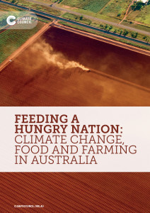 7 October 2015, Climate Council: The price, quality and seasonality of Australia’s food is increasingly being affected by climate change with Australia’s future food security under threat, our new report has revealed. Australia’s food supply chain is highly exposed to disruption from increasing extreme weather events driven by climate change, with farmers already struggling to cope with more frequent and intense droughts and changing weather patterns.
Agriculture – feeding the world
 March 2015, NASA GISS Science Brief, Study Assesses Fragility of Global Food System: If you were in the New York metropolitan area (the home of the NASA Goddard Institute for Space Studies) in the days after Hurricane Sandy, you might have experienced something seemingly unthinkable in 21st century America: empty food shelves at the supermarkets for days and days. New Yorkers believe that they can stand up to whatever life throws at them, yet this experience caught even the proudest natives off-guard…..Taking a step back, should we really be surprised by a disruption to our regional food system? More importantly, how concerned should we be about the stability of our global food system in a world marked by geopolitical, economic, and climatic uncertainties? Read More here
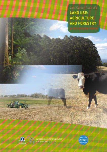 Zero Carbon Australia Discussion Paper: Land Use: Agriculture and Forestry: Emissions in the agriculture and forestry sectors in Australia are high and growing. The UNFCCC National Inventory Report suggests that sources of land use emissions, such as land clearing for agriculture and enteric (intestinal) fermentation from digestive processes in livestock, contribute 15% of national emissions. Australia’s land use sector is in a unique position to mitigate (reduce) climate impacts and take a leading role in addressing climate change. Agriculture and forestry are the only sectors of the Australian economy that can draw carbon dioxide out of the atmosphere by sequestering it in growing plants and in the soil. The agriculture and forestry sectors can mitigate climate impacts on the land, bringing prosperity to rural areas in the process. The Zero Carbon Australia Land Use report explores how this can be done.